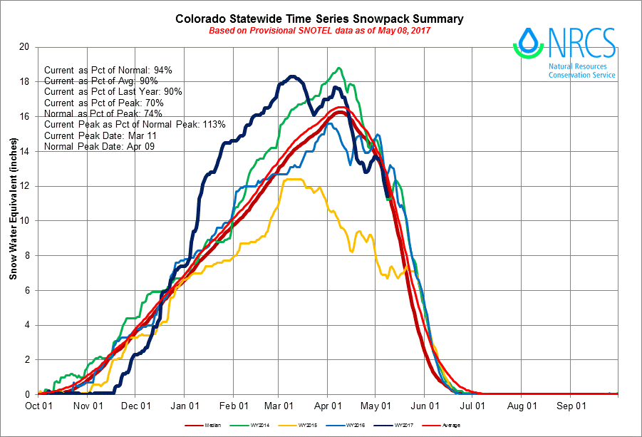
In the graph above, dark blue represents this water year. Dark red is the median, and light red is average.
In Colorado, snowpack serves as slow-release water storage. As it melts, it feeds streams, rivers, and reservoirs. So, naturally, municipal supply managers and other stakeholders pay particularly close attention to the snowpack levels come spring. Snowpack levels typically peak in April and provide a good gauge of water supply conditions in the months to come.
However, this year the snowpack peaked in early March and then a second peak occurred in April. This March was the warmest on record for Colorado, and the second warmest on record for the nation. Temperatures in Colorado were eight degrees above average, according to NOAA’s National Climate Report, and the state received 64 percent of average precipitation, according to the Colorado Water Availability Task Force.
This record warmth had an impact on snowpack. It contributed to earlier than normal melting and accelerated melt rates. Statewide, year-to-date snowpack as of April 19 was 91 percent of normal, down from 121 percent on March 17.
Reservoir storage remains good across Colorado, and some late April snowfall is slowing the melting trend. So it remains to be seen how much of an impact the early snowpack melt will have statewide. To monitor water availability this summer, visit the Colorado Drought Monitor website.
Images courtesy of the National Science Foundation


